              Observations on Air Quality following a Forest Fire
         From an aficionado who runs air sensors and builds air filters
                                 Bob Inouye
                                  8/22/2021
Three days ago I woke up at 1:00 a.m. to find fire coming up over the 800’ high ridge behind our isolated home in the forest. Trees were torching, and the burning line was working its way downhill:

Taking advantage of a bulldozer line and sprinkler sets, the Mesa Hotshot crew saved our house using kerosene drip torches and an incendiary flare gun to start a 2 mile long backfire:

The fire surrounding (but not touching) our home has burned out. Crews have worked day and night patrolling the line and digging out lingering smokes:

but flames still burn in stumps:

and plumes of smoke still drift up from smoldering hot spots:

Airflow in this canyon mouth is typically still at night and morning, then picks up mid-day to blow less smoky air in. But particulate can accumulate to high concentrations overnight.
I run several air quality sensors which report PM 2.5 levels, inside and out. Let me start with a disclaimer: these are not the federal EPA quality sensors that can cost thousands of dollars each. But with the benefit of correction factors calculated by the EPA, and with the redundancy that several individual sensors contribute here, this is the best (and only) data in the area. I believe it to be adequate data that gives good readings on our air quality. And it’s good enough that it is collected and reported on EPA websites.
Our outside PM2.5 sensors report to several websites. Purple Air quits reporting data when concentrations get above a certain level. On their site we can still see our inside sensor (at 197 ug/m3 this morning) but not the outside sensor data:

The federal fire.airnow.gov site does still report data from our outside sensor, even in these extreme conditions, putting the present hourly average at 2,059 ug/m3 Pm2.5:

(The break in data on August 19th represents the hours Pacific Power de-energized their lines during the fire.)
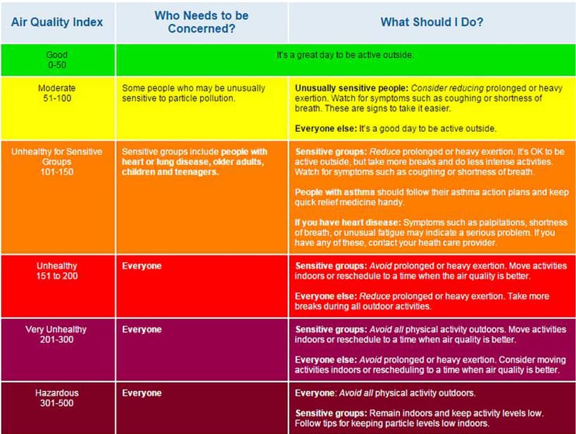
For non-scientists, EPA converts this raw PM 2.5 data to the more user-friendly color-coded air quality system, putting their NowCast in the Maroon color range, or an AQI of 1,429:

It’s clear that this 1,429 NowCast figure is absurdly high since the EPA’s “Hazardous” range (maroon color) starts at 300 and in theory only goes up to 500:
If you go outside the air is not breathable. I tried it once; you immediately start coughing as if you’d swallowed something the wrong way. Wearing an N95 mask I can take a quick photo of a very bright spotlight beam trying to penetrate the early morning haze:

Inside we do an exceptional job of filtering the home air, so it’s usually well down in the ideal green zone. But now the in-home sensor reports 245 ug/m3, which WAQA translates to 331 in the maroon “Hazardous” zone:

I wear the N95 mask inside, but they don’t fit Penny very well:

so three large portable air cleaners are gathered in one closed room for us:

I lack a sensor in this room, but with these filters cranking on high, I can comfortably remove the mask to drink a cup of coffee. Still, the eyes start to itch.
By noon a breeze will likely start to clear this some. And over the coming days the remaining smokes should peter out, and the overnight accumulations will cease. At some point, this remote lightly populated area will get back to its typical exceptionally clean forest air. But for now, these post-fire days surround us with more challenging air quality than the fire day itself.
Bob Inouye
8/22/2021